
Topography Mapping
SuavAir is able to produce cm level accurate georeferenced maps, 3D models and point clouds that can be used to measure ground data. This can be used for as-built surveys, landslide monitoring, and change detection on volumes at industrial sites.
Digital Surface Models
Digital surface models (DSMs) and Digital Elevation Models (DEMs) can be created using photogrammetry surface from motion analysis or LiDAR sensors. DSMs show the elevation model based on the surface on the land including buildings, trees, and other equipment. DEMs are elevation models of bare earth with trees, and other surface structured removed. Using LiDAR technology, we are able to penetrate forest canopies to get high accuracy DEMs.


Monitoring the volume change in an asbestos dumping area in an active landfill over several years
Site monitoring
Elevation models can be used for monitoring change at landfills, construction sites, gravel pits and perform volumetric calculations. Monitoring how a site changes over time due to natural or intentional activities is important in order to understand what is happening at a site. Out cm level accurate mapping is able to determine give you numbers and locations of just what is happening at your project site. We can create profiles, reference points, contour lines that can be compared over a variety of timeframes.
As Built Surveys
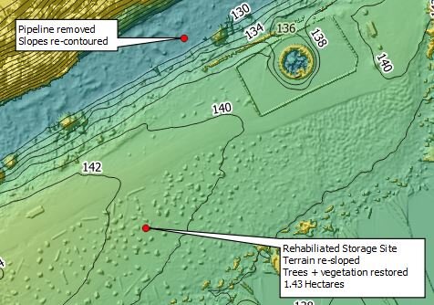
As built showing the staging site was re-contoured and the pipeline corridor was restored to follow the design
Our data can be used as documentation for showing the final design of an excavated or established site. The data can be reviewed at any time in the future as proof that the engineered design was followed at the time of the as built survey.