
Burn Severity Maps & Surveys

The 2023 wildfire season was the most destructive in BC’s recorded history with 2.84 million hectares. Many forest licensees have cutblocks under a silvicultural obligation that have been impacted by wildfires. We can help map those forestry cutblocks, determining the burn severity to plan for re-forestation and site preparation, and identify any areas that may now be NP. With RPFs on staff, we can also complete the Section 108 application for funding relief in RESULTS, or Forest Carbon Iniative (FCI) funding for previously declared FG Blocks. SuavAir has completed over 3,000 hectares of wildfire survey to date.

Accurate Mapping
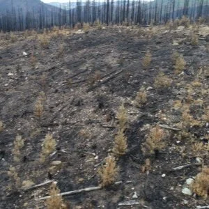
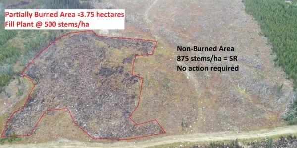
Wildfire often burns irregularly, leaving some areas scorched while other areas are lightly burned or untouched completely. Aerial mapping can identify these areas for stratification to determine the correct management activity. After flying the block, we use our accredited surveyors to get boots on the ground to verify the stocking and soil conditions. Accurate mapping to the 0.01 of a hectare in NSR areas ensures the correct number of trees are ordered and planted.

High-Resolution Documentation
If applying for Section 108 funding, aerial imagery is an asset for documenting post-wildfire site conditions of the block. We can create high-resolution, orthomosaic maps to measure areas as well as ground truthing to support recommendations. Aerial imaging is ideal as it can be reviewed by all stakeholders from an office setting.
Increased Efficiency = Lower Costs
Our drone surveys are fast and efficient as we can survey hundreds of hectares a day. This increased production allows us to have lower costs than traditional methods while still delivering an excellent survey. Companies will have updated information on the status of their silviculture obligations sooner and be able to plan the necessary management activities.
Our trained pilots are also RPFs and Silviculture Acreditted Surveyors (SAS). We use the UAVs as a tool for assessments, yet we will investigate issues on the ground as we see them. Making the right decisions by having the best data is the foundation for good forest management.