Stockpile Volume Surveys
Tracking and monitoring stockpile volumes from numerous locations can be a challenge over time as inventory comes and goes. Managers need to know the volume of their stockpiles for inventory management, billing, and mining plans. SuavAir can accurately and precisely determine the volume of stockpiles through creating digital 3D models to take measurements in.
To create these 3D models, SuavAir captures multiple high resolution photos from different angles. These pictures are stitched together with photogrammetry software to create a 3D model from millions of points. Measurements are then taken of the slopes and lengths of the piles to calculate accurate volumes.

Multiple stockpiles with ongoing inventory management from the plant
Stockpile Volume Surveys
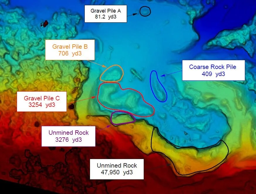
Large stockpiles of material (gravel, dirt, coal, pulp chips, etc) can be quickly measured and surveyed using digital surface models. Stockpile inventory can be done sites with dozens of unique stockpiles or a site with just one pile. Clients receive a list of the calculated piles, along with a map showing the pile locations to confirm measurements are taken in the right areas.


Volume Harvested
Excavated pits can also be measured to determine the volume removed. Likewise, they can also be measured to determine the amount of unharvested material remaining. UAV surveys are more accurate than traditional surveying techniques due to the millions of points used and offer a cheaper and safer alternative.
Highly Accurate Data
Rather than just a limited number of survey points like traditional surveying, our point clouds are made up of millions of points. More points to measure with results in extremely detailed survey results. We had the opportunity to compare our drone survey numbers to a traditional survey and the numbers were nearly identical.

Quick Data Turnaround
We understand that our clients need stockpile survey data to make important decisions. We guarantee that within 24 hours of the survey, we will deliver a report that has all the necessary calculations. All reports will include regular camera imagery and the elevation DSM imagery and a detailed volume analysis for each stockpile. 3D models can be made available online through a cloud portal if the client wishes to view the data themselves.